The Street
What is today a one-way street from 15th to 16th Street very likely started out as a two-way roadway. Plat maps do not show any carriage houses behind Caroline Street properties because lot sizes were small. Brick carriage houses did exist, and still do, behind two houses on the north side of T Street sharing the alley with Caroline (behind 1512 and 1518/20 Caroline). According to a 1903 real estate map for the city, several frame stables once existed behind U Street properties that shared the common alley with residences on the north side of Caroline. These stables were opposite the rears of 1501, 1503, 1505, 1507, and 1509 Caroline.[1]
|
|
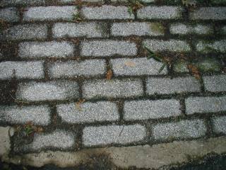
An 1893 map of the City of Washington indicates that Caroline Street had a paved surface of "asphalt and coal tar".[2] This surface was probably not too durable and was replaced at some point by stone blocks like those pictures above.
Horse-drawn vehicles were the norm of the day. Correspondence and other memoranda from July and August 1897, in archival files of the Department of Public Works (DPW), attest to this fact. John R. Croggon, a resident of 1511 Caroline, wrote the city's Engineer Commissioner and the Department of Health indicating that a public well existed near or in front of his house and that he believed the water was not potable. Croggon wanted the well closed, and the Health Department's test indicated that the water was not fit for drinking. Further, Croggon indicated to city officials that horses were left to stand in the street while their drivers drank from the public well. Often the men who stopped for water used foul language. They frequently lingered so long that their horses urinated in the street, creating a foul stench.[3] (Happily, our current minor problem with taxis parked on the street has no odors associated with it.) City officials seemed to have responded fairly quickly to Mr. Croggon's request for assistance.
A decade later in 1907, DC Commissioner H. B. F. MacFarland issued an order closing all 62 of the public wells remaining in the city, because of water pollution. This brought to an end the use of wells and springs that had helped provide the city with water since early in the 19th century. These sources were no longer necessary because the Army Corps of Engineers had built an aqueduct from Great Falls, Maryland, to provide the city with an adequate water supply from the Potomac River. This work was done following the Civil War.[4]
The same city DPW Engineering files at the DC Archives provide a glimpse of other concerns on the part of street residents at the end of the 19th and in the early years of the 20th century. There were several requests to have trees trimmed, and one to have a tree replaced in front of 1511. On September 29, 1898, a Mrs. H. H. Bliss inquired about the extension of Caroline Street to 14th Street. The documentation supporting this request could not be found in DC Archives' files, but we know today that the street was not extended. In February, 1902, the Chesapeake & Potomac Telephone Company requested permission to lay a telephone conduit from 16th Street to the "alley Square 190." C&P Telephone made another request in June, 1911, for a telephone conduit for the street. Telephone conduit work on Caroline Street continued into the 1920s. These same archival records appear to indicate that the street was "completed" (perhaps that means paved, or maybe it means that the telephone work was finished) in the mid-1920s. The last record in the file shows that electric streetlights existed on Caroline Street by at least November 1927.[5]
The automobile and its impact on Caroline Street came much later. The street was already a one-way route in the early 1950s, but from west to east. To reduce the use of the street as a shortcut to 15th Street by morning commuters (15th at the time was one way south in the morning rush), the direction was reversed by the early 1970s.[6] Today, street residents compete daily with visitors headed to nearby businesses or the Metro for scarce street parking spaces. Parking is especially acute on weekends when patrons of the growing number of restaurants and clubs on nearby U Street make evening parking on Caroline almost impossible. As a result, many street residents have converted their backyards into off-street parking for one or two vehicles. Some residents avoid the issue entirely by not having a car at all.
[1] 1903 Baist Real Estate Map for Washington, DC. (Plate 17).
[2] City of Washington Statistical Map Showing Different Varieties of Street Pavements, 1893. James M. Good and Laura Burd Schiavo, Washington Images, Rare Maps and Prints from the Albert H. Small Collection. The Historical Society of Washington, D.C., 2004., p. 79.
[3] Records of the Department of Public Works, Engineering files, DC Archives, 1300 Naylor Court, NW.
[4] John Clagett Proctor, LLD, "Proctor's Washington and Environs", a column written for the Washington Star, 1949.
[5] Cross Reference Card, Records of the Department of Public Works Engineering files, DC Archives, 1300 Naylor Court, NW.
[6] Interview with Mrs Caroline Evans, 2 June 2004.
Last update 11 July 2004
Copyright Richard Busch, 1993, 2004-5
Blanket permission for downloading and reproduction for personal use is given.
Any commercial use without explicit written permission is prohibited.
home | previous page - the name | next page - architecture | contact